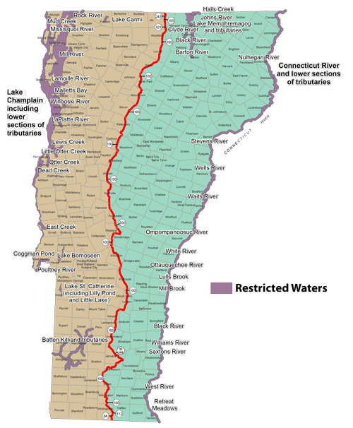
Below is the list of Restricted Waters. Once bait has been used on a restricted water, that water is the only place that bait can be used.

Connecticut River (R–CT) defined as all waters of the river including the bays, setbacks, and tributaries, only to the first highway bridge crossing said tributaries on the Vermont side. Also including the following tributaries to the following boundaries:
- Ottauquechee River to the top of the North Harland Dam in the town of Hartland
- West River to the Interstate 91 highway bridge in the town of Brattleboro, including Retreat Meadows, Brattleboro
Lake Champlain (R–LC) (see 10 App. §122 Section 5.0) including setbacks at the same level and tributaries to the following boundaries:
- Dead Creek to Panton Road bridge in Panton
- East Creek to the falls in Orwell (downstream of Mount Independence Road)
- Lamoille River to the top of the first dam (Peterson Dam) in Milton
- LaPlatte River to the falls in Shelburne (under Falls Road bridge)
- Lewis Creek to falls in North Ferrisburgh (just upstream of Old Hollow Road)
- Little Otter Creek to falls in Ferrisburgh Center (downstream of Little Chicago Road)
- Malletts Creek to the first falls upstream of Roosevelt Highway (US 2 and US 7) in Colchester
- Mill River in Georgia to the falls in Georgia (just upstream of Georgia Shore Road bridge)
- Missisquoi River to the top of Swanton Dam in the Village of Swanton
- Mud Creek to the dam in Alburg (just upstream of Route 78 bridge)
- Otter Creek to the top of the dam in the city of Vergennes
- Poultney River to Central Vermont Power Dam at Carver Falls in West Haven,including Coggman Pond, West Haven
- Rock River to the first Canadian border crossing
- Winooski River to the Winooski One hydropower dam west of Main Street (US 7) in Winooski and Burlington
Lake Bomoseen (R)
Lake Carmi (R) including the outflow to the top of Mill Pond Dam in the town of Franklin
Lake Memphremagog (R–M) including the following tributaries:
- Clyde River to the top of the abandoned Mill Dam immediately upstream of the Number 1, 2, 3 hydroelectric powerhouse in Newport City
- Barton River to the downstream side of the US Route 5 bridge southernmost and closest to the village of Barton
- Johns River to the downstream edge of the bridge on Beebe Road (TH #3) in the town of Derby
- Halls Creek to the headwaters
- Black River to the top of the falls at Old Harmon Mill in the town of Coventry
Lake St. Catherine (R) including Lilly Pond and Little Lake
Battenkill (R–BK) and its associated tributaries including but not limited to:
- Bourn Brook
- Bromley Brook
- Chunks Brook
- Dry Brook
- Green River
- Lye Brook
- Mad Tom Brook
- Mill Brook
- Roaring Branch
- Warm Brook
- West Branch Batten Kill
- White Creek
